
Columns of Hercules

According to myth, the Columns of Hercules were located at the Strait of Gibraltar and marked the western extreme of the inhabited world. Tradition has it that the words ‘nothing further beyond’ were written on the pillars. Roman versions of the myth tell how Hercules, with his superhuman strength, crashed through Mount Atlas to reach the Garden of Hesperides, joining the Mediterranean Sea to the Atlantic Ocean. The split rock became known as the Columns of Hercules.
Golden Fleece
The myth of Jason and the Golden Fleece is a tale of quest, adventure and superhuman heroism. Jason and his Argonauts sailed westwards from Greece in their ship the Argo. Their quest was to find and bring back the magical fleece of the Golden Ram. Along the way Jason encountered both love and duplicity, but finally brought the fleece back to Greece.
On our map the Golden Fleece is shown on the coast of the Black Sea. It is possible that the legend has a connection with the colonisation of the Black Sea coast.
Labyrinth
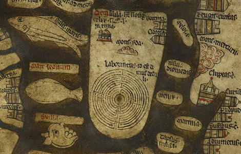
In Greek mythology the Cretan labyrinth was built by Daedalus to contain the Minotaur, a bull-headed, man-eating monster. The myth tells how King Minos pledged to appease the Minotaur’s voracious appetite by regular offerings of seven young men and women, but Theseus entered the labyrinth and heroically slayed the monster.
In the Middle Ages, many cathedrals had a labyrinth set out in the floor paving. Pilgrims would walk the labyrinth as a spiritual pilgrimage, and it is likely that this sort of labyrinth would have been known to medieval viewers of the map.
Camp of Alexander the Great
This splendid edifice is labelled ‘Camp of Alexander the Great’. In the Middle Ages, legends abounded about the strange adventures and heroic deeds of Alexander the Great. His conquest of the Persian Empire and domination of the known world was a popular tale. The map has a number of references to his story. As well as this camp, of particular note is the restraining wall Alexander is reputed to have built to save the world from the destructive evil of the Sons of Cain.
Christ in Majesty
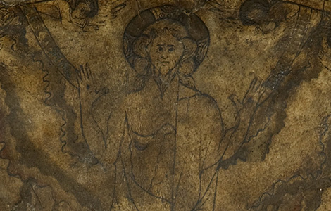
Christ sits enthroned in majesty above the world, as though surveying all of creation. He holds up his hands to show the wounds of the crucifixion, and the spear wound in his side is also visible. On his right, the saved rise up out of their coffins and enter the gates of heaven. On his left, the damned are stripped bare, chained together and dragged towards the gates of hell, symbolised by the opened mouth of a great beast.
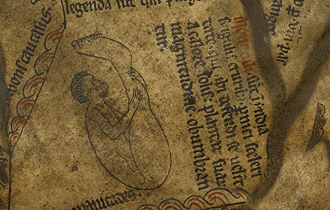
Eden
The earthly paradise, Eden, is represented by a circular island at the eastern extreme of the world (the top). The drawing on the map shows an Eden that is inaccessible to humanity. It is surrounded by a ring of fire, separated from the land masses by water, walled and battlemented, and its gates are firmly closed. Within the wall, Eve holds out her hand to take the fruit of the tree of knowledge from a demon-headed serpent who lurks in the branches of the tree.
Noah’s Ark

The Bible tells how, angry with the wickedness of humanity, God decided to cause a great flood to wipe out mankind. The only man untainted by wickedness and worthy of saving was Noah. So God asked Noah to build a great ship (the ark) to save the animals of the world and his own family. Inside the drawing of the ark we can see a number of beasts and three people, including a bearded man who could be Noah.
The Red Sea and the Exodus

On the map there is a clear pathway through the Red Sea. This marks the route of the children of Israel out of slavery in Egypt and towards the ‘Promised Land’. If you follow the meanderings of this route, you’ll see where the Israelites got lost in the desert and then, finally, found their way to the ‘Promised Land’. For medieval Chistians, this story spoke of passing through the water of Baptism, undertaking the journey and wanderings of life, and then, finally, finding salvation.
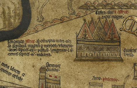
Babylon and the Tower of Babel
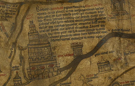
The imposing city of Babylon, with its five elaborate storeys, is the largest structure on the map. The Bible gives details about Babylon’s impressive size and construction, and similar details appear in the text on our map.
As well as representing the city of Babylon, the topmost tower of the drawing on the map is labelled ‘Tower of Babel’. The story of the Tower of Babel tells how, in their arrogance, people sought to build a city with a tower so high that it would reach the sky, but God punished this overreaching pride, causing humanity to speak in different languages.
Camel
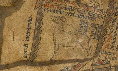
The map’s camel is a bactrian, with two humps. He stands to the south of the Memarnau mountains, East of the Amu Darya river, and seems to be very pleased with himself! The text on the map reads: ‘Bactria has extremely strong camels that never wear out their feet’. Medieval books of beasts (bestiaries) often included an illustration of a camel and a description of its habits, saying things like: ‘they hate horses and only drink muddy water’ or ‘they can live for a hundred years’.
Lynx
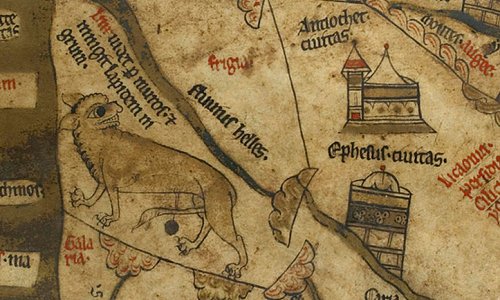
On our map, the lynx prowls along the southern coast of the Black Sea looking backwards over its shoulder. Like many medieval illustrations of lynxes, it urinates a precious stone. On the map, the stone is reported to be black, but some medieval books of beasts (bestiaries) say that this stone is ‘flame coloured and similar to a carbuncle’. When the map was made, as now, lynxes were understood to have very keen eyesight. The map says: ‘The Lynx sees through walls and urinates a black stone.’
Elephant
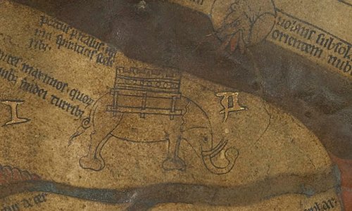
Like many other elephants in medieval illustrations, this one has a tower. Medieval books of beasts (bestiaries) describe how Indian and Persian soldiers constructed wooden towers on the backs of elephants to use as fighting platforms. The map’s elephant is drawn with long tusks, but the text on the map seems to confuse tusks and teeth, saying that the elephant’s ‘teeth are believed to be ivory’. Some bestiaries claim that elephants can live for 300 years and are afraid of mice.
Unicorn

In medieval books of beasts (bestiaries), the unicorn is often described as a small but fierce creature that can fight elephants. Despite this ferocity, though, bestiaries tell how the unicorn could be overcome by an innocent maiden, who could calm his wildness so that he laid his head in her lap and became harmless. Some bestiaries link the unicorn to Christ. On our map the unicorn is called a monoceros.
Blemmyes
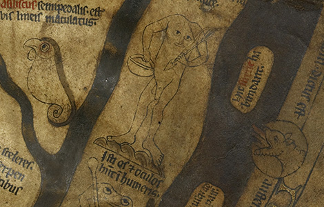
In the Middle Ages there were many travellers’ tales telling of Blemmyes. The Blemmyes were reported to be a war-like race with no head, but with their facial features in their chest. Alexander the Great was thought to have encountered Blemmyes in his campaigns, and they are even mentioned in Shakespeare’s Othello. One medieval writer says they are ‘like lawyers, who speak through their bellies’! On our map, a Blemmye holding a spear and a shield is located in Africa.
Sciapods
In the Middle Ages, stories circulated about Sciapods or Monoculi. Sciapods were reported to be a race of people with one very large foot that they used to shield themselves from the sun. Stories also told how these strange people moved extremely quickly on their one leg. On our map there are two Sciapods, one in India, and another on the extreme southern edge of the inhabited world.
Troglodites
Troglodites, or cave-dwellers, often featured in medieval illustrations. On the map, four Troglodites are drawn in Africa. Three of them are illustrated inside caves (one is eating a snake), while the fourth, a bearded man, appears to be wearing only a helmet. He rides a goat-like beast. The text on the map says that Troglodites are ‘very swift; they live in caves, eat snakes and catch wild animals by jumping on them.’
Cynocephali (Dog-heads)
Stories about men with the heads of dogs and barking voices are many and varied, and go back to classical antiquity. Some medieval travellers and writers describe the Cynocephali as ‘barbarians’, who can be tender one minute, but agressive and uncontrolled the next. In one medieval legend from Wales, the Cynocephali can be interpreted as werewolfs. In some other legends, St Christopher is reported to be a giant with a head like a dog.
Hereford
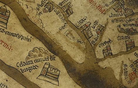
On the map, Hereford is pictured as a small, indistinct building on the river Wye. It seems to have been almost rubbed off the vellum, and some scholars think this might be due to the pointing fingers of Herefordians or pilgrims over the centuries as they located the city. Recent scientific tests on the map’s wooden frame (displayed in the exhibition) suggest that the map was probably made in or near Hereford.
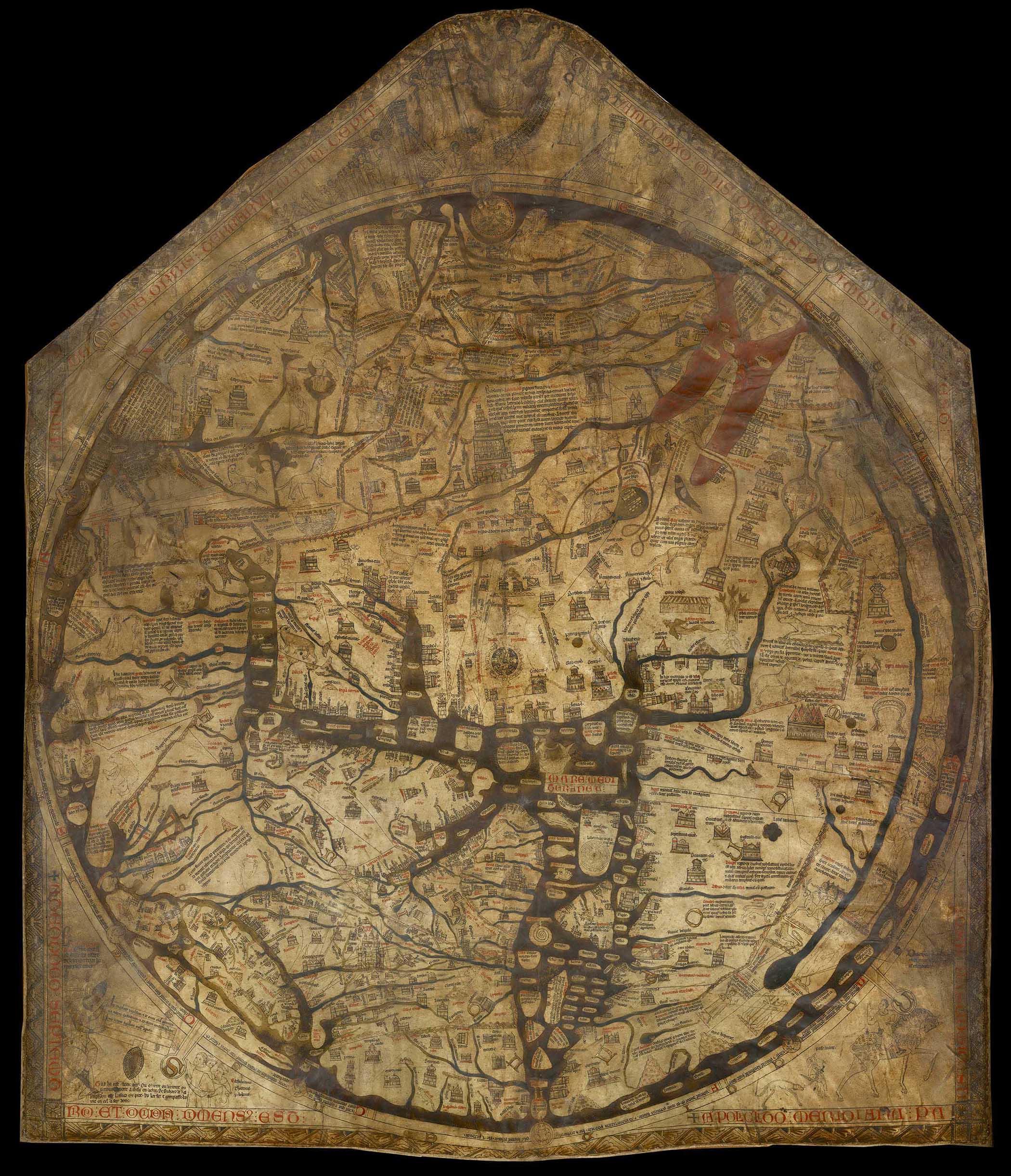
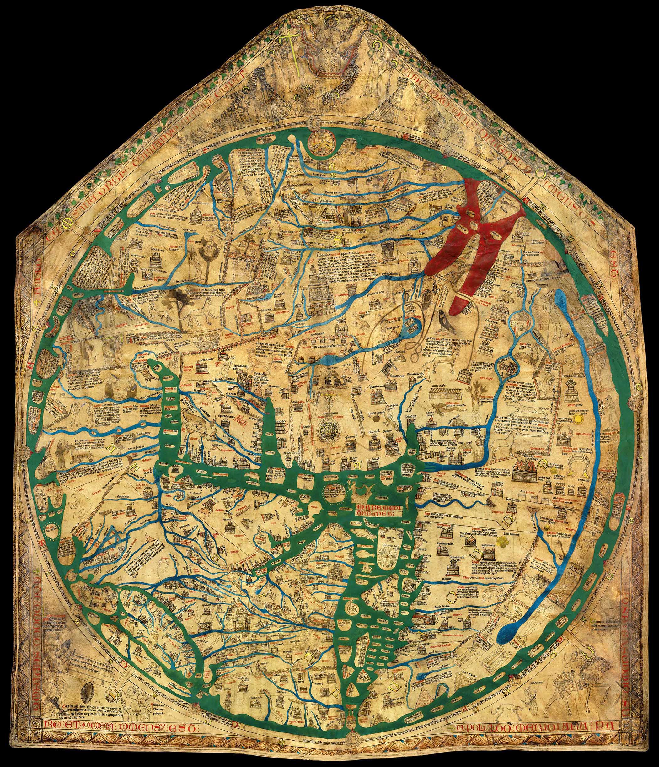
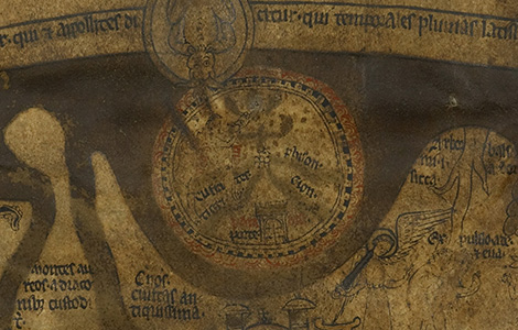
Jerusalem

Jerusalem, represented by a circlular battlemented wall enclosing eight towers or gates, is the place of the crucifixion and the centre of the map. The book of Ezekiel in the Old Testament of the Bible says: ‘Thus says the Lord God: This is Jerusalem; I have set her in the centre of the nations’, and the Hereford map is just one of a number of medieval maps that show Jerusalem as the centre of the known inhabited world.
Rome

Rome is very large on the map, and clearly important. It is where St Peter and St Paul were martyred. St Peter was the first Bishop of Rome, and popes who came after him were seen as his successors. In the Middle Ages, Rome was central to the spread of western Christianity. The text on the map reads: ‘Rome, head of the world, holds the bridle of the spherical earth.’
Paris
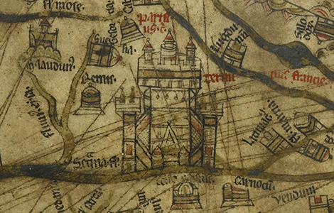
With its multiple towers and pinnacles, Paris is the largest and grandest structure in Europe. Its significance can perhaps be explained by its medieval university’s importance for the study of philosophy and theology. Many of the principal medieval theologians and religious leaders worked and studied in Paris, including St Thomas Cantilupe, bishop of Hereford 1275–1282. Sadly, at some time in the past, the area around Paris on the map has been badly scratched.
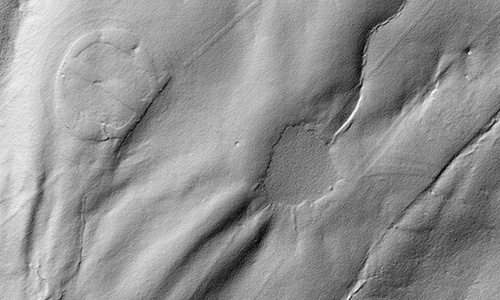
Tensions in Vellum

The map is drawn on a large sheet of vellum: a single calfskin, about 1.5 m high, 1.3 m wide and 0.7 mm thick. Vellum has a hair side (the outside when on the animal) and a flesh side (the inside) and is prone to cockle, because the hair side is naturally tauter than the flesh side. The Hereford Mappa Mundi is drawn on the flesh side of the skin, which explains why its undulations tend to balloon outwards. Here the undulations caused by this innate tension are clearly visible.
Vellum Preparation
Vellum (commonly also called parchment) is made from the skin of an animal, usually a calf, sheep or goat, but other skins, such as deer, were used in the Middle Ages. The process of making vellum is long and painstaking. The skin is washed, soaked in a solution of lime and water, scraped to remove the hair and flesh, then stretched whilst wet and pared with a crescent-shaped blade called a lunellum, before being allowed to dry and shrink; the paring process is repeated several times. Here the resulting clean, smooth and durable surface can be clearly seen.
Vascular Systems in Vellum
In the region of the map where Scotland appears, traces of the veins of the animal from which the skin was removed to manufacture the vellum can be clearly seen: a reminder that we are looking at the prepared skin of a beast.
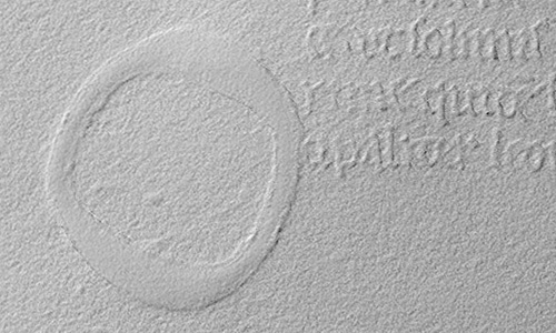
Central Perforation
This tiny hole, directly in the centre of Jerusalem, marks the centre of the circumferences both of Jerusalem itself and of the whole world. It was made by a tool for drawing circles, such as a compass.
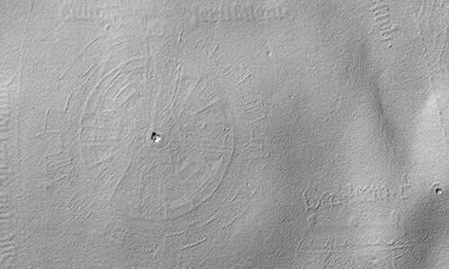
Labyrinth Perforation

This tiny hole, at the centre of the minotaur's labyrinth on the island of Crete in the Mediterranean, marks the centre of the circumference of the circular maze. It was made by a tool for drawing circles, such as a compass.
Depth Changes from Corrosion

All over the map, the pigments that have been used to colour it can be seen to be lying proud on the surface of the vellum, unlike dyes, which would have penetrated it. Without analysis using modern techniques such as Ramon spectroscopy, it is impossible to know precisely which pigments were used, but they are likely to have included minerals such as lapis lazuli or azurite (blue), or compounds such as vermillion (red). The seas would have originally been green, but the copper-based pigment has darkened and corroded, leaving areas within them standing proud. Here Sodom and Gomorrah appear to rise out of the Dead Sea.
Ink in Relief
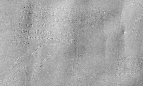
The writing, made in a good quality ink, still very black, can be seen to be standing proud of the surface. Evidence that the drawing was done first and the text added later is shown in areas like this, where the text has clearly been fitted around the drawing, in this case of a mythological beast called a yale.
Patch Repairs
The 3D scan shows up clearly the many repairs made to the map over the centuries. Here a patch of parchment has been pasted under a hole which may originally have been a flaw in the vellum caused by an insect bite to the animal when alive.
Gilded Capitals
Here the letter 'O' from the word 'Europa' (Europe - but actually placed over Africa) can be seen to be really three-dimensional. The letter is a versal, where the outline is drawn with a pen and then filled in. In this case the filling in is a built up base of sticky gesso on which gold leaf has been laid and then burnished.
Hereford Erased
Here, the image and text for Hereford can be seen to have been completely flattened, so that they hardly show up on the 3D scan, although traces of ink and pigment are still just visible. This is probably owing to the tens of thousands of visitors who pointed it out in the centuries before the map was covered by glass.
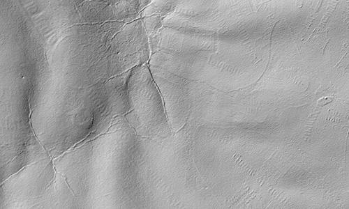
The Paris Scratches
Many lines have been drawn angrily through the city of Paris at some stage in the map's history, presumably because of anti-French feelings. It used to be thought that the lines were either score marks or the result of accidental damage from sharp objects having been placed against the map, but the 3D scan clearly shows that these lines are standing proud, and they look like other drawn ink lines: they are not accidental.